Weblog: Portland Cycle Tour: Portland > Woodland
<< Previous Entry | Next Entry >>
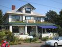
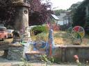
I had decided yesterday that I would start on my way to Seattle today, even though I didn't really want to leave the wonderful city of Portland. I took my time getting ready to leave in the morning, and by the time I got my laundry done and all my stuff packed up, it was noon. Before actually leaving the city, I checked out a couple of last things I wanted to see, such as a cob memorial built for a cyclist who was hit by a truck that I read about in the Stormwater Cycling pamphlet, which was quite touching.
To get out of the city, I followed the bike route north along the Wilamette waterfront and then a road that parellels I-5 (which I recognized from a road trip I did to San Francisco a couple of years ago as a place where we got lost on a gas stop). It looks like they've just about finished an expansion of the MAX along this road. I stopped off on Jantzen Island (between Portland and Vancouver WA on the Columbia River) at REI, which is much like MEC in Canada. There I picked up an item that I've wanted but could not find before: an attachment that goes into a wide-mouth Nalgene bottle so that you can drink out of it in a moving car without it spilling everywhere. When I left REI, my front tyre was flat. Rather than patch it, I put in one of my spare tubes because all through the trip the front tyre had a slow leak, and every morning I had to pump it up a bit to maintain enough pressure, which got to be annoying.
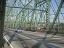
I took the I-5 bridge to Vancouver WA, which is basically a suburb of Portland (but also the fourth-largest city in Washington State). I stopped at a grocery store to get some juice and a better map of the state (up to now I had been using a free WSDOT map), but the place didn't have a map and the proprietor directed me to a camera-supply store called Tymer (I think) to get a map. It turned out one of the guys there had done cycle tours in the area and gave me lots of good advice about the route to take initially. He also recommended I not cycle to Seattle, because the whole Tacoma-Seattle corridor is developed and there are no nice roads into the city, but I still plan to head to Seattle anyway. The map they had wasn't that much better than the free one I already had, but I bought it anyway because the advice was worth it.
I cycled north out of town on Hazel Dell Ave and stopped for a swim at the lake in Salmon Creek Park. After Hazel Dell crossed I-5, I took the Old Pacific Highway north to Woodland. The Old Pacific Highway was a lovely route, meandering through the hills with little traffic. There were many blackberry bushes along the way, and they all were completely full of perfectly ripe berries, so I spent a lot of time gorging myself. Along parts of the road there were signs that people had put up saying "no spray," or some more verbose, like "don't spray toxic chemicals on our blackberries," so I guess there must be some kind of roadside spraying going on. I hope I didn't ingest too much pesticide with the berries. Maybe I have been exposed to enough of the stuff due to applying it this summer that I've built up a resistance (either that or a sensitivity). Near Woodland, I got confused at a junction (my map doesn't have street names on it) and wound up cycling an extra 8 mi roundtrip along a road that went east.
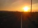
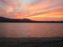
It was getting a bit late at this point, so I spent quite a long time scouting around Woodland for a place to sleep and also trying to find a road other than I-5 that goes north. The Old Pacific Highway, which could be difficult to find because it had other names in some places, abruptly ended in a gravel pit near I-5 (which I guess must have used its route). I asked several locals, and none of them knew of any way north other than the freeway. It was also difficult to find a nice place to sleep, though I had found a couple of places that probably would have been okay, I decided to take Dike Access Road to try to find a place along the Columbia River. Everywhere that looked suitable had "no trespassing signs", but finally my perseverence payed off and I found a sandy road near an RV park that led to the river. I asked someone walking his dog if this was private land, and he told me it was probably county land and should be fine if I sleep there, so I got a beautiful spot along the river, and witnessed a spectacular sunset. It didn't look like it would rain, so I just put my sleeping bag on a tarp on the sand and went to bed.
The day was sunny and once again very hot. It was warm enough in the evening that even in the wind I sat reading without a shirt on at dusk and I wasn't cold.
Distance: 81.21km today,
910.62km total;
Average Speed: 17.2km/h;
Time: 04:41:24
Posted
on
Wed, 3 Sep 2020
at
Woodland,
WA,
US
(altitude 1m)
(map/google earth)
Copyright 1995-2006 Emanuel Borsboom.
All content on this site is licensed under a
Creative Commons License,
unless otherwise specified.